Navigate the Waters With the Best Marine GPS

Safe traveling requires proper and accurate navigation, and this particularly holds when you are out on the water. Whether you are out on a fishing spree or riding a schooner, boat, or yacht exploring, a marine GPS keeps you on your intended route. So, the elite marine GPSes in 2024 should always make your priority checklist when heading out into the water.
Whether you are an amateur sailor or an experienced professional on the boat, a GPS utilizes satellite information to ensure that you are always on course. That said, finding the perfect marine GPS can be a tedious process, with the devices getting more advanced and feature-packed. Our comprehensive guide has all the answers, especially if you don’t know whether it’s a chart plotter, fish finder, or a mere tracker that you need.
Our Top Picks
- Best Overall: Humminbird HELIX 5 CHIRP GPS Shop Now ➔
- Most Accurate GPS: Garmin ECHOMAP Marine GPS Shop Now ➔
- Most Intuitive Interface: Simrad Cruise Marine Chartplotter Shop Now ➔
- Buying Guide: Marine GPS
- 1 What Is a Marine GPS?
- 2 Chartplotter vs Fishfinder
- 3 Essential Factors in a Marine GPS
- 4 Device durability goes a long way
- 5 Choosing the right kind of GPS device
- 6 Screen dimensions and interface matters
- 7 Must-Have Marine GPS Features
- 8 Pre-loaded maps and charts
- 9 Sonar scanners and transducers
- 10 More advanced features
- People Also Asked
- Related Reviews
The Premier Marine GPS Models of 2024 in Detail
Best Overall
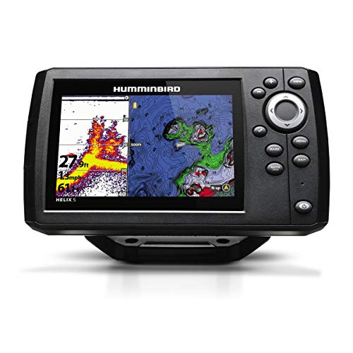
This highly efficient and affordable marine GPS from Humminbird functions as both a chart plotter and fish finder, so you can always be ready for your next marine voyage. Features like higher resolution displays, enhanced target separation, and controlled image noise make the navigation via the Humminbird HELIX 5 GPS much more seamless.
This particular fish finder, with CHIRP sonar technology, ensures an in-depth screening up to 1,000 feet at multiple frequencies. It comes with preloaded maps and data, marking all possible entryway points, buoys, marinas, shores, and hazards. Furthermore, the built-in cartography tool allows advanced chart plotting, and the WAAS technology provides accurate fixes of global positioning within 8.2 feet. With amazing features rivaling its counterparts on a low budget, this is the best marine GPS on our list.
Pros
- MicroSD card allows additional map upgrades
- 5-inch widescreen for easy navigation
- Suitable for small to large-sized vessels
- Two different display modes
Cons
- Lacks a screen cover
Most Accurate GPS
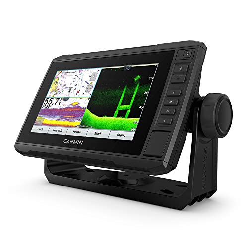
If you are looking for a fish finder and chart plotter combo, the Garmin ECHOMAP Marine GPS will be your ultimate navigation companion. This device offers exceptionally advanced and accurate GPS technology that instantly updates your coordinates. It’s an efficient navigation device that provides extensive coverage of US coastal areas.
The 7-inch wide sunlight-readable, tiltable screen and the heavy-duty mounting system make this device a perfect partner for venturing out into the ocean. Meanwhile, its high-tech sonar scanning Panoptix feature with GT24 transducers provides a clear vision of what’s underneath your vessel and around you. Additionally, the ECHOMAP GPS also allows you to create personalized maps.
Pros
- Features preloaded maps for US coasts
- Easy to access menu
- High-definition visual quality
- Enhanced target separation with CHIRP sonar technology
Cons
- Requires upgrade for areas outside the US coasts
Most Intuitive Interface
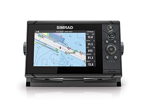
Are you on the lookout for an advanced chart plotter that offers sophisticated hardware and software features at an affordable price range? Then the Simrad Cruise Chartplotter is the answer to your navigation woes. This marine GPS will keep you on course with the preloaded US coastal maps and enhanced chart support from Navionics and C-Map when cruising through the water. Plus, the 83/200 transducer is preprogrammed to provide enhanced depth tracking automatically.
This GPS makes navigation a breeze with its intuitive control menu, rotary dial, and keypad design. The menu allows you to create customized routes and access information such as speed, temperature, and depth reading. What’s more, this topographical navigation device is particularly great for use over rough seas to always stay on course.
Pros
- Available in three different screen dimensions
- Works in high seas and coastal waters
- Split-screen for access to essential information
- Easy installation and mounting
Cons
- The depth finder needs improvement
Buying Guide: Marine GPS
You can’t have an oceanic adventure without a sophisticated navigation system onboard. Whether heading into the lake for fishing or breaching the coastal territories to experience rough seas and waves, a marine GPS prioritizes your safety and keeps you on your intended course.
Unfortunately, the newer features, cutting-edge technology upgrades, and different types can be overwhelming. Should you opt for a mounting device or a handheld, portable variant? Do you need a fish finder-chart plotter combo, or is just a GPS tracker enough for your voyage?
All of your questions are valid, and this buying guide addresses everything you need to know before getting yourself a marine navigation device.
What Is a Marine GPS?
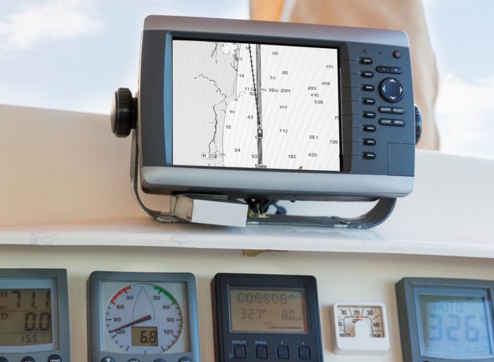
Marine GPS is an umbrella term for navigation devices that track a vessel’s location in coastal bodies. The primary function of a global positioning system (GPS) device is to pinpoint the location of any boat over a body of water and provide information about the surroundings. Marine GPS tools include different variants such as GPS radio, chart plotters, and fishfinders.
Chartplotter vs Fishfinder
The two major categories of marine GPS are chart plotters and fishfinders, each serving specific functions. Mariners often opt for hybrid GPSes, which offer a combination of both variants in a single device. While getting a marine GPS that functions as both a chart plotter and fish finder enhances the device’s effectiveness, it also costs you a few extra bucks.
So, it’s important to explore the difference between both marine GPS variants. That way, you can determine whether you need a chart plotter, a fishfinder, or a hybrid.
A chart plotter is a navigation tool that utilizes GPS satellites to pinpoint your location when you are in a coastal area or surrounded by water. The chart plotting device utilizes map coordinates in relation to your speed and directional data to ensure that you are on your intended course. Thus, it minimizes the risk of getting lost or losing track when you are in the ocean.
Fishfinders are specifically for mariners who venture out into the water for fishing purposes. This device utilizes sonar scanning technology and transducers to pinpoint areas with a shoal of fish. If you are a dedicated angler, you’ll appreciate the chart plotter/fishfinder combo.
Essential Factors in a Marine GPS
Device durability goes a long way
Marine GPS devices are mostly a one-time investment that may cost you some serious money. Therefore, you want a device that runs its natural course and provides optimal performance with perfect durability.
Most importantly, a premium-quality marine navigation device should be waterproof or water-resistant since wave splashes are expected in a vessel. Additionally, you can use protective covers over the GPS to keep it safe from water exposure and enhance its durability. A marine GPS with a waterproof rating ranging from IPX 0 to IPX8 ensures functionality, even when faced with moisture, humidity, or water exposure.
Choosing the right kind of GPS device
Besides chart plotters and fish finders, there are other types of marine GPS based on their mounting style and portability. The different kinds of marine GPS you can opt for can be a hand-held device, dash-mounted GPS, or a portable option, depending on your vessel size and usage.
Portable GPS devices make a great navigation companion for smaller boats like kayaks. Meanwhile, dashboard-mounted GPS devices work better for larger vessels with better features and sophisticated navigation measures.
Screen dimensions and interface matters
When you are aboard a vessel, the device’s screen dimension and interface matter a lot for ease of accessing data and information. Larger screen dimensions are more user-friendly and convenient for mariners.
Must-Have Marine GPS Features
Pre-loaded maps and charts
Your marine GPS can cost you much more if it has pre-installed maps and charts, but they’re very useful. Preloaded maps make navigation more accurate, providing all the essential information regarding the area, hazards, and entry points. Also, users have to opt for map upgrades if they wish to utilize the device on international coasts, so most GPS devices come with an additional SD card for that purpose.
Sonar scanners and transducers
Suppose you are going for a fishfinder GPS. In that case, you need a high-quality transducer system and sonar scanning technology to provide accurate data on what’s beneath the water’s surface. One of the most recent technologies, CHIRP sonar, ensures proper depth range and is quite a popular feature in marine GPSes.
More advanced features
When your marine GPS has the best features, you can expect enhanced navigation and optimal performance. Wi-fi connectivity, distress signals, and a VHS transmitter further elevate the navigation experience. However, the choice of additional features depends on what you require from your marine GPS device.
People Also Asked
What is the purpose of CHIRP technology?
Abbreviated for compressed high-intensity radar pulse (CHIRP), this sonar tech utilizes multiple frequency levels, providing detailed imaging and clarity of what’s beneath the surface. CHIRP technology is most effective for fishfinders.
Do I need to get map upgrades and additional charts?
Most marine GPS manufacturers offer preloaded maps of the US and surrounding coastal areas. Map upgrades aren’t required if you are in the US and adjoining territories. But, if you are exploring international coasts, you might need some additional map and chart upgrades.
Is it difficult to understand the marine GPS interface?
If you are a nautical newbie, a marine GPS interface can have a bit of a learning curve. With the complex functions navigational GPS devices serve, it’s understandable for mariners to take their time to understand the device’s interface. That said, reputed brands and manufacturers always ensure an easy-to-decipher interface, high-definition visuals, and intuitive menu controls to get the most out of navigation devices.
Article Contributors
SAIL Magazine Review Team reports on best-selling products in sailing and boating. SAIL Magazine is reader-supported: When you buy through links on our site, we may earn an affiliate commission. Artificial Intelligence (large language models) may have been used in the research and creation of the content.
To ensure questions about product testing or a specific article are addressed, please contact aimperiapt@gmail.com


